
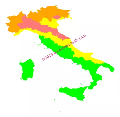
What are the Italian snow zones according to Eurocode 1 (UNI EN 1991-1-3/AN) ?
On the map of the national annex, the Italian territory is divided by provinces into three snow zones identified from 1 to 3. The snow zone 1 is subdivided into two to account for the Alpine or Mediterranean influence.
| Zone | I-M | I-A | II | III |
|---|---|---|---|---|
| Characteristic value of snow on the ground without elevation sk,0 | 1.50 kN/m2 | 1.50 kN/m2 | 1.00 kN/m2 | 0.60 kN/m2 |
How to determine the influence of elevation on the ground snow load in Italy ?
Distinct variation laws must be applied depending on each zone.
Snow loads are calculated as follows:
Up to 200m:
\[\displaystyle s_{k} = s_{k,0}\]Above 200m:
Zone I-M
\[\displaystyle s_{k} = 1.35 \cdot \left[ 1 + \left( \frac{a_{s}}{602} \right)^{2} \right]\]Zone I-A
\[\displaystyle s_{k} = 1.39 \cdot \left[ 1 + \left( \frac{a_{s}}{728} \right)^{2} \right]\]Zone II
\[\displaystyle s_{k} = 0.85 \cdot \left[ 1 + \left( \frac{a_{s}}{481} \right)^{2} \right]\]Zone III
\[\displaystyle s_{k} = 0.51 \cdot \left[ 1 + \left( \frac{a_{s}}{481} \right)^{2} \right]\]where A is the elevation of the site.
How to adjust the ground snow load according to return period in Italy ?
\[\displaystyle s_{n} = s_{k} \cdot \left[ \frac{ 1 – V \cdot \frac{\sqrt 6 }{\pi} \cdot [\ln(-\ln(1-P_{n})) + 0.57722] } {(1 + 2.5923 \cdot V)} \right]\]- Pn is the annual probability of exceedence :
- dwl is the design working life, in years.
- V is the coefficient of variation of annual maximum snow load with V=0.2 for a recurrence interval less than 50 years and V=0.6 for a recurrence interval greater than 50 years.
- It should not be applied for annual probabilities of exceedence greater than 0,2 (i.e. return period less than approximately 5 years).
Example of results given by the software Eurocodes Zoning
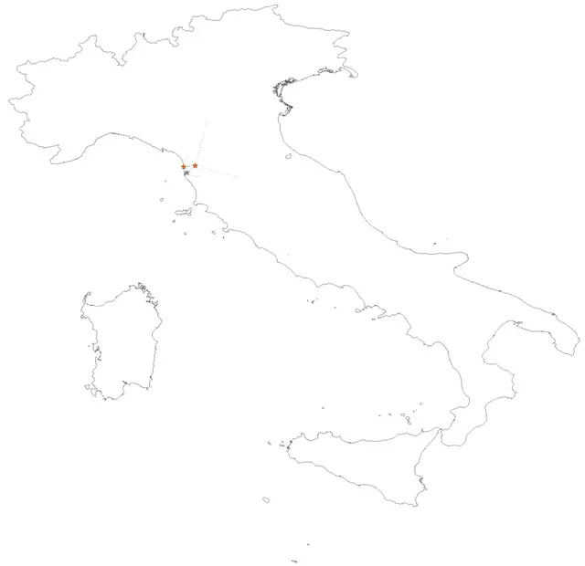
B1 – Localization
- Coordinates in World Geodetic System 1984 (WGS84) 10.5188° , 43.7455°
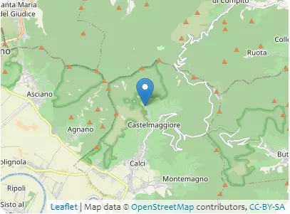
Address 56011 Calci, Toscana
B2 – Elevations
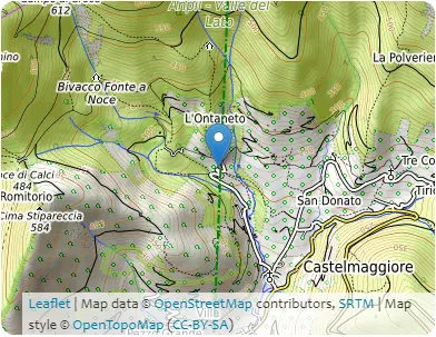
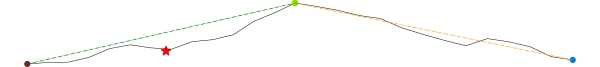
| Coordinates | 10.5181°, 43.7303° | 10.5198°, 43.7596° | 10.5198°, 43.7596° | 10.5179°, 43.7901° |
|---|---|---|---|---|
| Elevations | 60m | 798m | 798m | 109m |
| Obstacle effective height H | 738m | 689m | ||
| Slope actual length Lu / Ld | 3261.4m | 3379.8m | ||
| Slope angle Φ | 22.6% | 20.4% | ||
| Horizontal distance site/top x | 1571.5m | |||
| Elevation at the place of construction | 216m | |||
B3 – Building
- Type of building: monumental building
- Design working life category: 50 years
- Max height: 10m
- Orientation from North: 15°
B4 – Terrain categories
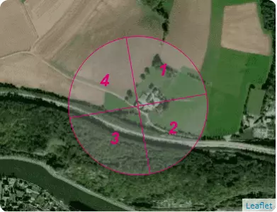
| Sectors | 1 | 2 | 3 | 4 |
|---|---|---|---|---|
| Categories | C | C | B | B |
| Sectors | 1 | 2 | 3 | 4 |
|---|---|---|---|---|
| Sector definition | from 330 ° to 60 ° | from 60 ° to 150 ° | from 150 ° to 240 ° | from 240 ° to 330 ° |
| Distance to shore | > 100 km | > 100 km | 21.3 km | 19.5 km |
| Exposure category | III | III | III | III |
C1 – Snow
UNI EN 1991-1-3 Appendice nazionale 24/09/2010
- Zone : III(sk,0 = 0.6 kN/m²)
- Criteria for zoning : Pisa, Toscana
- Characteristic value of snow on the ground at the relevant site : sk,216 = 0.613 kN/m²
- Ground snow load with a return period of 50 years : s50 ans = 0.613 kN/m²
C2 – Wind
UNI EN 1991-1-3 Appendice nazionale 24/09/2010
- Zone : 3(vb,0 = 27.0 m/s)
- Criteria for zoning : Pisa, Toscana
| Sectors | 1 | 2 | 3 | 4 |
|---|---|---|---|---|
| Sector definition | from 330 ° to 60 ° | from 60 ° to 150 ° | from 150 ° to 240 ° | from 240 ° to 330 ° |
| Value of the basic wind velocity from the map vb,0 | 27.0m/s | |||
| Elevation above which wind velocity increases vb,0 | 500m | |||
| Fundamental value of the basic wind velocity vb,0 | 27.0m/s | |||
| Shape parameter K | 0.138 | |||
| Exponent n | 1 | |||
| Annual probability of exceedence p | 0.02 | |||
| Probability factor cprob | 1.0 | |||
| Directional factor cdir | 1.0 | 1.0 | 1.0 | 1.0 |
| Basic wind velocity vb | 27.0m/s | 27.0m/s | 27.0m/s | 27.0m/s |
| Reference roughness length z0,II | 0.05m | |||
| Roughness length z0 | 0.1m | 0.1m | 0.1m | 0.1m |
| Terrain factor kr | 0.2 | 0.2 | 0.2 | 0.2 |
| Height above ground z | 10.0m | |||
| Minimum height zmin | 5.0m | 5.0m | 5.0m | 5.0m |
| Roughness factor cr(z) | 0.921 | 0.921 | 0.921 | 0.921 |
| Obstacle type | isolated hills | |||
| Exposure type | downwind | – | upwind | – |
| Factor depending on the type and dimensions of the obstacle s max | 0.444 | 0.0 | 0.282 | 0.0 |
| Orography factor * co(z) | 1.181 | 1.0 | 1.128 | 1.0 |
| Mean wind velocity vm(z) | 29.4m/s | 24.9m/s | 28.0m/s | 24.9m/s |
| Turbulence factor kl | 1.0 | 1.0 | 1.0 | 1.0 |
| Standard deviation of the turbulence σv | 5.4m/s | 5.4m/s | 5.4m/s | 5.4m/s |
| Turbulence intensity Iv(z) | 0.184 | 0.217 | 0.193 | 0.217 |
| Air density ρ | 1.25kg/m3 | |||
| Exposure factor ce(z) | 2.706 | 2.138 | 2.532 | 2.138 |
| Peak velocity pressure qp(z) | 1233.0N/m2 | 974.0N/m2 | 1153.8N/m2 | 974.0N/m2 |
| Peak wind velocity for Serviceability Limit States vp(z),SLS | 159.9km/h | 142.1km/h | 154.7km/h | 142.1km/h |
| Peak wind velocity for Ultimate Limit States vp(z),ULS | 195.8km/h | 174.1km/h | 189.4km/h | 174.1km/h |